Competitive Fortnite GeoGuessr requires transitioning away from superficial visual cues and instead mastering the mathematical coordinate systems, kinetic velocities, and architectural standards of the Unreal Engine. By systematically exploiting spatial telemetry, historical asset metadata, and server-client network mechanics, elite players can achieve pixel-perfect accuracy on any target map.
Mathematical Foundations of Point Allocation and Distance Decay
Traditional browser-based geography platforms calculate distance across a spherical Earth using the Haversine formula, modeling the planet with a mean radius R of 6,371 kilometers. The shortest distance d between the player’s guess coordinates and the exact target coordinates is calculated using the following mathematical model:
d = 2R · arcsin(sqrt(sin²(delta-phi/2) + cos(phi1) · cos(phi2) · sin²(delta-lambda/2)))
Where delta-phi and delta-lambda represent the radian difference in latitude and longitude, while phi1 and phi2 denote the respective absolute latitudes of the guess and target coordinates in radians. The resulting distance d is mapped to a scoring decay curve:
S = 5000 · e^(−10 · d/D)
Where S is the final score out of a 5,000-point ceiling, d is the calculated error distance, and D represents the total diagonal distance across the map’s coordinate boundary. Substitutions reveal that to secure a maximum score of 5,000 points, the displacement d must remain within 1/100,000 of the total diagonal D. On a global world map, this threshold is approximately 149.18 meters, although the engine defaults to a hardcoded 5,000-point reward for any guess within 25 meters.
Browser-based engines such as Lostgamer.io substitute exponential curves with a smoother Gaussian decay function to avoid severe point penalties for minor spatial errors near the target coordinates. This scoring function is derived as follows:
S = S(max) · exp(−0.5 · (x/sigma)²)
Where S(max) represents the scoring ceiling, typically 2,500 or 5,000 points, x represents the flat Euclidean distance in meters, and sigma is the map scale constant. The scale variance sigma² is computed by isolating user-configured boundary limits:
sigma² = −s² / (2 · ln(d(decay)))
Where s is the absolute scaling parameter and d(decay) represents the targeted decay multiplier at that distance.
Native Client Mechanics and Unreal Engine Coordinate Projections
Inside native Fortnite Creative experiences (such as the OG Edition designed by ZernaCreations and accessed via code 4749-0459-3824), coordinate calculations occur in real-time server-side through custom Verse scripts. To prevent vertical altitude displacement from penalizing players on multi-tiered structures, the script utilizes a horizontal projection logic. This algorithm strips all Z-axis values to calculate the flat horizontal distance d(2D) in Unreal Units (UU). Because one UU corresponds to exactly one centimeter, the formula divides the result by 100 to convert to meters and applies a floor operation to output an integer value:
d(2D) = floor(sqrt((X(guess) − X(target))² + (Y(guess) − Y(target))²) / 100)
Where X(guess) and Y(guess) represent the player’s horizontal coordinate inputs, and X(target) and Y(target) represent the exact objective coordinates.
Kinematic Constants and Tile Metric Conversions
Engine physics and player collision guidelines operate on a rigid centimeter-to-meter conversion pipeline. These spatial metrics govern horizontal transit times and modular asset snapping parameters:
| Parameter | Unreal Units (UU) | Metric Dimension | Engine Definition |
|---|---|---|---|
| Grid Sizing Standard | 512 UU | 5.12 meters | Fortnite default modular asset snapping limit |
| Modular Wall Height | 384 UU | 3.84 meters | Vertical structural wall boundary dimension |
| Modular Wall Thickness | 24 UU | 24 centimeters | Midpoint offset dividing positive and negative axes |
| Mini-Map Grid Block | 25000 UU | 250 meters | Standard block column and row boundary limit |
| Jogging Velocity | 410 UU/s | 4.1 meters/second | Maximum default player horizontal movement rate |
| Sprinting Velocity | 550 UU/s | 5.5 meters/second | Maximum default player tactical sprint rate |
| Grid Crossing Time | N/A | 45.45 seconds | Duration required to sprint 250 meters horizontally |
To prevent light bleeding at structural seams, developers must overlap assets using a 24-centimeter thickness split symmetrically into 12 centimeters along positive and negative axes. Player movement speeds are also mathematically bound. Substituting the metric width of a single grid square d(grid) of 250 meters and standard sprinting speed v(sprint) of 5.5 meters per second, the absolute transit time T(sprint) is calculated as:
T(sprint) = d(grid) / v(sprint)
Evaluating this quotient yields a grid-crossing duration of approximately 45.45 seconds, establishing a reliable mechanical reference for distance estimation.
Celestial Mechanics and Environmental Physics Indicators
Isolated drops devoid of structures require players to rely on global environmental engine properties to establish orientation.
Sun pathing rises in the East and sets in the West. During dawn and dusk transitions, the engine renders a distinctive warm orange tint on the respective horizon, allowing immediate identification of true North.
Procedural skybox cloud layers are explicitly coded to travel continuously from West to East. Observing cloud drift can resolve heading confusion under overcast conditions.
Hydrological flow rules dictate that standard water currents run outward from high-elevation central massifs toward the coast. However, the river system in the Southeastern quadrant features an anomalous inward-flowing current toward the center of the map. Observing water moving inland immediately restricts the coordinates to this quadrant.
Historical Epoch Dating and Seasonal Metadata
Dating static images is a critical mechanical step during multi-era matches. Each major historical era features highly distinct visual assets, mobility items, and environmental structures:
| Season Epoch | Active Timeline | Primary Visual Biomes | Key Traversal Items | Key Telemetric Visual Indicators |
|---|---|---|---|---|
| Chapter 6 Season 1 | Dec 2024 to Feb 2025 | Japanese Shrines and Plains | Standard traversal gear | Cherry blossom flora and Giant Turtle POI |
| Chapter 7 Season 1 | Nov 2025 to Mar 2026 | Coastal deserts and Red-Rock Canyons | Wingsuits and Wave Launchers | Self-Revive Devices and Classified Canyon |
| Chapter 7 Season 3 | Jun 2026 to Active | High-velocity neon urban zones | Tactical sprinting boots | Active Sprite nodes and John Wick skin |
| OG Season 9 | Jun 2026 to Active | Classic grasslands and melting snow biomes | Classic jump pads | Frozen Devourer asset at Polar Peak |
Chapter 6, Season 1 (鬼HUNTERS) ran from December 1, 2024, to February 21, 2025, and is visually marked by Japanese mythology-inspired shrines, plains, and cherry blossom biomes. Chapter 7, Season 1 launched on November 29, 2025, introducing coastal deserts, Red-Rock Canyons, and stylized POIs such as Wonkeeland and Sandy Strip. This era is also identifiable by Wingsuits, Wave Launchers, and Self-Revive Devices.
Chapter 7, Season 3 (Runners) introduced glowing physical Sprites that attach to player models to provide real-time buffs. These include Water Sprites providing shield regeneration in water, Earth Sprites enhancing chest drops, and Fire Sprites triggering explosive bursts. While game file data-mining confirms Earth Sprites boost high-tier chest drop rates, the exact probability multiplier is not exposed in public server files. The era is also marked by the Mythic Zero Point Sprite deploying a Bubble Shield Jr., the King Sprite boss, and specific cosmetics. Evaluating the active player avatar is equally essential, as comparing visual outfits against a historical database of Fortnite cosmetics will instantly restrict the timeline to a specific patch.
Fortnite OG Season 9 commenced on June 25, 2026, recreating classic Chapter 1 terrain with some of the best landing spots and altering Polar Peak. This melting process exposes the frozen skeletal body of the Devourer Kaiju, serving as a definitive chronological marker.
Network Topology, Session Security, and Cheat Vector Mechanics
The interface architecture of browser-based platforms exposes session data across the network transport layer. When a match initializes, the backend generates a unique session identification string known as a Universally Unique Identifier (UUID), which is exposed directly inside the client address bar. Here, the alphanumeric string following the final slash represents the session UUID.
To render the 360-degree panorama, the backend must transmit coordinate data directly to the client browser upon loading. This design creates a security vulnerability where automated scripts intercept XMLHttpRequests (XHR) to read raw coordinate JSON payloads containing exact latitude, longitude, and (X,Y) coordinate vectors before visual assets render. These scripts simulate programmatic pin placement on the exact target location.
To mitigate coordinate hijacking, server architectures implement robust API defenses. The gateway restricts query endpoints by requiring a cookie-based _ncfa authentication token. Additionally, submission rates are programmatically monitored. Programmatic submissions that bypass human velocity thresholds trigger an API shadowban, causing the server to return undefined coordinate data, which neutralizes the script’s calculations.
Core UI Steps for Multi-Platform Gameplay Navigation
Executing multi-platform matches requires specific UI navigation paths depending on the selected engine framework:
- Lostgamer.io Navigation: Load the web domain, choose between Singleplayer or Multiplayer, configure a specific era map (such as Chapter 1, Season 4), adjust round parameters from one to 40, and select the optional AI Boss Raid challenge.
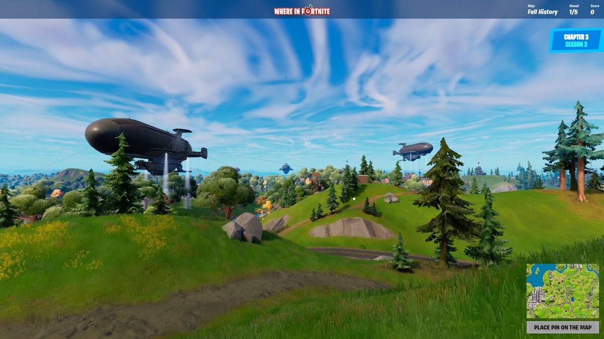
- Where in Fortnite Navigation: Navigate to the native web client, configure customizable parameters including round timers, pan limits, or zoom restrictions, and toggle Night Mode to test advanced acoustic and silhouette triangulation skills.
- UEFN Creative Client Navigation: Launch the Fortnite game client, navigate directly to the Discover tab, input the dedicated island code 4749-0459-3824, spawn inside the lobby environment, examine the panoramic skybox, and confirm map placements by shooting the interactive coordinate grid.
Strategic Pitfalls and Professional Competitive Meta-Strategies
Competitive matches highlight critical mechanical traps and advanced strategies utilized by elite players.
- The Altitude Displacement Trap: In 2D browser interfaces, players often overcompensate for vertical depth in mountainous biomes (such as Classified Canyon) and misalign their horizontal pins. Conversely, in UEFN environments, players frequently fail to realize that the zless custom function completely ignores vertical elevation, leading to unnecessary horizontal adjustments.
- Grassland Biome Misidentification: The transition of art styles across historical map revisions has created visually uniform fields. Players who rely solely on default grass textures often place pins on incorrect map epochs.
- Farmland Miscalculation: Highly uniform agricultural zones (such as Frenzy Farm) contain minor soil color shifts and crop row directions that players routinely miscalculate, leading to significant distance penalties.
- No Move Silhouette Triangulation: Champion division No Move rules restrict camera rotation and zoom, forcing players to orient themselves entirely by comparing background Level of Detail (LOD) assets and mountain silhouettes.
- Night Mode Landmark Emitters: Under near-zero visibility conditions, players must rely exclusively on visual glow emitters (such as neon signs and rift particles) and spatial audio steps to triangulate positions.
- Region-Guessing Frameworks: High-tier players apply systematic asset-profiling techniques. For example, classifying localized variants of wooden fences, brick structures, and small generic shacks enables players to immediately distinguish visually identical biomes across map variations.


Updated: Jun 24, 2026 02:42 pm